


les pénitents des Mées

lhomme.ph
User GUIDE
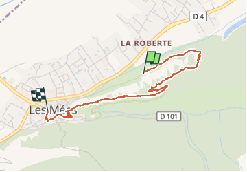

Length
3.7 km

Max alt
589 m

Uphill gradient
150 m
Km-Effort
5.9 km

Min alt
418 m

Downhill gradient
195 m
Boucle
No
Creation date :
2025-07-30 07:50:21.232
Updated on :
2025-07-30 10:45:14.799
2h54
Difficulty : Easy

FREE GPS app for hiking
 SityTrail
IGN / Geographical institutes
SityTrail Plus
The world is yours!
About
Trail Walking of 3.7 km to be discovered at Provence-Alpes-Côte d'Azur, Alpes-de-Haute-Provence, Les Mées. This trail is proposed by lhomme.ph.
Positioning
Country:
France
Region :
Provence-Alpes-Côte d'Azur
Department/Province :
Alpes-de-Haute-Provence
Municipality :
Les Mées
Location:
Unknown
Start:(Dec)
Start:(UTM)
739430 ; 4879837 (31T) N.
Comments