


2025-07-30 Etampes -Dourdan

Lucquiaud
User
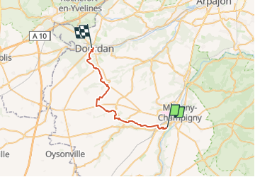

Length
27 km

Max alt
164 m

Uphill gradient
345 m
Km-Effort
31 km

Min alt
67 m

Downhill gradient
308 m
Boucle
No
Creation date :
2025-07-31 07:14:34.518
Updated on :
2025-07-31 18:02:26.349
2h09
Difficulty : Difficult

FREE GPS app for hiking
 SityTrail
IGN / Geographical institutes
SityTrail Plus
The world is yours!
About
Trail Mountain bike of 27 km to be discovered at Ile-de-France, Essonne, Étampes. This trail is proposed by Lucquiaud.

Positioning
Country:
France
Region :
Ile-de-France
Department/Province :
Essonne
Municipality :
Étampes
Location:
Unknown
Start:(Dec)
Start:(UTM)
437609 ; 5364108 (31U) N.
Comments