


PIERREPONT

patdecosnes
User
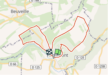

Length
9.5 km

Max alt
316 m

Uphill gradient
153 m
Km-Effort
11.6 km

Min alt
232 m

Downhill gradient
154 m
Boucle
Yes
Creation date :
2025-07-31 11:58:53.0
Updated on :
2025-07-31 14:39:29.952
2h21
Difficulty : Medium

FREE GPS app for hiking
 SityTrail
IGN / Geographical institutes
SityTrail Plus
The world is yours!
About
Trail Walking of 9.5 km to be discovered at Grand Est, Meurthe-et-Moselle, Pierrepont. This trail is proposed by patdecosnes.
Positioning
Country:
France
Region :
Grand Est
Department/Province :
Meurthe-et-Moselle
Municipality :
Pierrepont
Location:
Unknown
Start:(Dec)
Start:(UTM)
696598 ; 5477107 (31U) N.
Comments