


Ferrieres-14km

ZAMBAUX
User
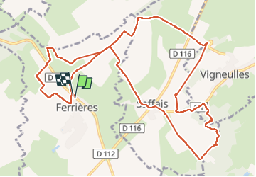

Length
13.4 km

Max alt
350 m

Uphill gradient
256 m
Km-Effort
16.8 km

Min alt
255 m

Downhill gradient
257 m
Boucle
Yes
Creation date :
2025-07-31 11:54:32.068
Updated on :
2025-07-31 15:25:38.176
3h30
Difficulty : Difficult

FREE GPS app for hiking
 SityTrail
IGN / Geographical institutes
SityTrail Plus
The world is yours!
About
Trail Walking of 13.4 km to be discovered at Grand Est, Meurthe-et-Moselle, Ferrières. This trail is proposed by ZAMBAUX.
Positioning
Country:
France
Region :
Grand Est
Department/Province :
Meurthe-et-Moselle
Municipality :
Ferrières
Location:
Unknown
Start:(Dec)
Start:(UTM)
300291 ; 5381783 (32U) N.
Comments