


43 le tour du Mézenc et le sommet 12/07/23

silvestreclaudine
User
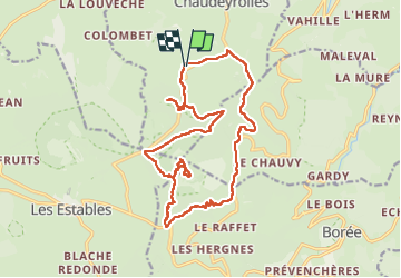

Length
19.5 km

Max alt
1740 m

Uphill gradient
628 m
Km-Effort
28 km

Min alt
1305 m

Downhill gradient
628 m
Boucle
Yes
Creation date :
2025-07-12 07:42:34.006
Updated on :
2025-07-31 17:38:09.63
6h03
Difficulty : Very difficult

FREE GPS app for hiking
 SityTrail
IGN / Geographical institutes
SityTrail Plus
The world is yours!
About
Trail Walking of 19.5 km to be discovered at Auvergne-Rhône-Alpes, Haute-Loire, Chaudeyrolles. This trail is proposed by silvestreclaudine.
Description
départ Chaudeyrolles.
GPS indispensable, des passages de sentiers hors balisages.
Photos


Positioning
Country:
France
Region :
Auvergne-Rhône-Alpes
Department/Province :
Haute-Loire
Municipality :
Chaudeyrolles
Location:
Unknown
Start:(Dec)
Start:(UTM)
594018 ; 4976393 (31T) N.
Comments