


Mont Geroux

FamilleTeste
User
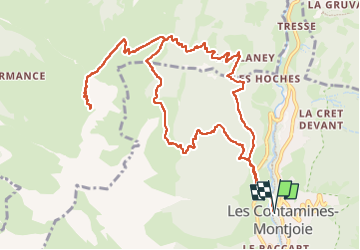

Length
14.2 km

Max alt
2288 m

Uphill gradient
1308 m
Km-Effort
32 km

Min alt
1120 m

Downhill gradient
1304 m
Boucle
Yes
Creation date :
2025-07-29 09:00:46.697
Updated on :
2025-07-31 19:12:19.858
6h12
Difficulty : Medium

FREE GPS app for hiking
 SityTrail
IGN / Geographical institutes
SityTrail Plus
The world is yours!
About
Trail Walking of 14.2 km to be discovered at Auvergne-Rhône-Alpes, Upper Savoy, Les Contamines-Montjoie. This trail is proposed by FamilleTeste.
Positioning
Country:
France
Region :
Auvergne-Rhône-Alpes
Department/Province :
Upper Savoy
Municipality :
Les Contamines-Montjoie
Location:
Unknown
Start:(Dec)
Start:(UTM)
323365 ; 5076787 (32T) N.
Comments