


franchevelle

PatriceCocuaud
User
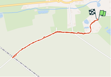

Length
2.2 km

Max alt
317 m

Uphill gradient
31 m
Km-Effort
2.6 km

Min alt
299 m

Downhill gradient
31 m
Boucle
Yes
Creation date :
2025-07-31 18:49:45.36
Updated on :
2025-07-31 19:22:15.863
30m
Difficulty : Very easy

FREE GPS app for hiking
 SityTrail
IGN / Geographical institutes
SityTrail Plus
The world is yours!
About
Trail Walking of 2.2 km to be discovered at Bourgogne-Franche-Comté, Haute-Saône, Franchevelle. This trail is proposed by PatriceCocuaud.
Positioning
Country:
France
Region :
Bourgogne-Franche-Comté
Department/Province :
Haute-Saône
Municipality :
Franchevelle
Location:
Unknown
Start:(Dec)
Start:(UTM)
309564 ; 5290281 (32T) N.
Comments