Trail Walking Priziac - 2025-07-31_22h13m01_Cirkwi-Les-Chapelles-a-Priziac---Circuit-n-21 - Photo

2025-07-31_22h13m01_Cirkwi-Les-Chapelles-a-Priziac---Circuit-n-21

© OpenStreetMap contributors
Length
Length
13.1 km
Max alt
Max alt
179 m
Uphill gradient
Uphill gradient
234 m
Km-Effort
Km-Effort  
16.2 km
Min alt
Min alt
106 m
Downhill gradient
Downhill gradient
233 m
Boucle
Boucle
Yes
Creation date :
2025-07-31 20:13:01.211
Updated on :
2025-08-02 19:05:34.027

(0 Reviews)

Walking
Walking
3h50
Difficulty : Medium

Scan this QR Code to open this trail in the SityTrail application

FREE GPS app for hiking

Logo SityTrail SityTrail

IGN / Geographical institutes

Download SityTrail from the App Store Download SityTrail from Google Play

Logo SityTrail SityTrail Plus

The world is yours!

Download SityTrail from the App Store Download SityTrail from Google Play Download SityTrail on Huawei AppGallery

About

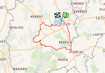
Trail Walking of 13.1 km to be discovered at Brittany, Morbihan, Priziac. This trail is proposed by neoroll44.

Description

Un circuit assez sportif, au départ du lac du Bel-air et de sa base nautique. Empruntez des sentiers à travers bois, au cours desquels vous découvrirez notamment les chapelles de Lotavy et de Saint-Nicolas. 14 km. Balisage jaune. Retrouvez cet itinéraire dans le topo-guide "La Bretagne à pied". En vente en librairie et sur www.ffrandonnee.fr/page de vente du topo.

Elevation profile

Photos

Positioning

Country:
France
Region :
Brittany
Department/Province :
Morbihan
Municipality :
Priziac
Location:
Unknown
Start:(UTM)
469142 ; 5323242 (30U) N.


Close
My subscriptions