


Sait Laurent en gâtine ouest

dporcher
User
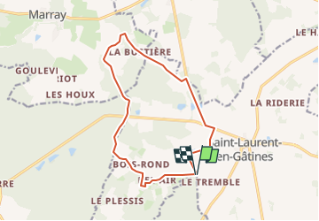

Length
13.4 km

Max alt
176 m

Uphill gradient
150 m
Km-Effort
15.3 km

Min alt
122 m

Downhill gradient
148 m
Boucle
Yes
Creation date :
2025-07-31 21:16:24.356
Updated on :
2025-07-31 21:17:10.855
3h29
Difficulty : Difficult

FREE GPS app for hiking
 SityTrail
IGN / Geographical institutes
SityTrail Plus
The world is yours!
About
Trail Walking of 13.4 km to be discovered at Centre-Loire Valley, Indre-et-Loire, Saint-Laurent-en-Gâtines. This trail is proposed by dporcher.
Positioning
Country:
France
Region :
Centre-Loire Valley
Department/Province :
Indre-et-Loire
Municipality :
Saint-Laurent-en-Gâtines
Location:
Unknown
Start:(Dec)
Start:(UTM)
331354 ; 5271955 (31T) N.
Comments