


saint lary visnegues tremzaygues G4

LouisROGER
User GUIDE
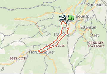

Length
10.5 km

Max alt
986 m

Uphill gradient
316 m
Km-Effort
14.7 km

Min alt
810 m

Downhill gradient
318 m
Boucle
Yes
Creation date :
2025-08-01 07:28:43.188
Updated on :
2025-08-01 13:40:51.608
6h10
Difficulty : Difficult

FREE GPS app for hiking
 SityTrail
IGN / Geographical institutes
SityTrail Plus
The world is yours!
About
Trail Walking of 10.5 km to be discovered at Occitania, Hautespyrenees, Vignec. This trail is proposed by LouisROGER.
Positioning
Country:
France
Region :
Occitania
Department/Province :
Hautespyrenees
Municipality :
Vignec
Location:
Unknown
Start:(Dec)
Start:(UTM)
280920 ; 4744423 (31T) N.
Comments