


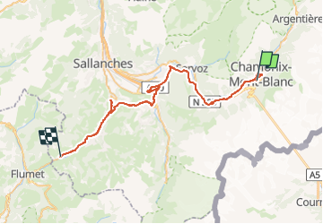
Excursion Chamonix

FOUCAULT
User

Length
48 km

Max alt
1113 m

Uphill gradient
1013 m
Km-Effort
62 km

Min alt
579 m

Downhill gradient
1032 m
Boucle
No
Creation date :
2025-08-02 10:17:40.0
Updated on :
2025-08-02 17:16:34.206
3h20
Difficulty : Unknown

FREE GPS app for hiking
 SityTrail
IGN / Geographical institutes
SityTrail Plus
The world is yours!
About
Trail Car of 48 km to be discovered at Auvergne-Rhône-Alpes, Upper Savoy, Chamonix-Mont-Blanc. This trail is proposed by FOUCAULT.
Description
Le 3 août 2025
Positioning
Country:
France
Region :
Auvergne-Rhône-Alpes
Department/Province :
Upper Savoy
Municipality :
Chamonix-Mont-Blanc
Location:
Unknown
Start:(Dec)
Start:(UTM)
334622 ; 5087107 (32T) N.
Comments