


29_botsorhel_menhir

jab31
User
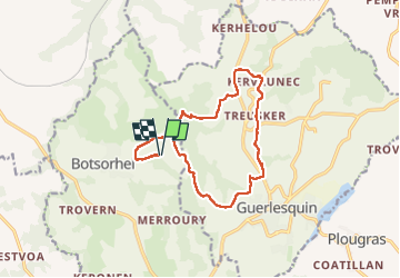

Length
13.9 km

Max alt
254 m

Uphill gradient
311 m
Km-Effort
18 km

Min alt
125 m

Downhill gradient
311 m
Boucle
Yes
Creation date :
2025-07-27 12:53:35.246
Updated on :
2025-08-02 19:25:54.914
3h04
Difficulty : Medium

FREE GPS app for hiking
 SityTrail
IGN / Geographical institutes
SityTrail Plus
The world is yours!
About
Trail Walking of 13.9 km to be discovered at Brittany, Finistère, Botsorhel. This trail is proposed by jab31.
Description
le menhir de kerhellou
Positioning
Country:
France
Region :
Brittany
Department/Province :
Finistère
Municipality :
Botsorhel
Location:
Unknown
Start:(Dec)
Start:(UTM)
453935 ; 5375210 (30U) N.
Comments