


gta jour 25

yvesconnes
User
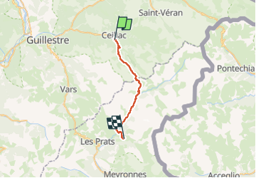

Length
25 km

Max alt
2696 m

Uphill gradient
1516 m
Km-Effort
44 km

Min alt
1590 m

Downhill gradient
1263 m
Boucle
No
Creation date :
2025-08-02 06:29:56.403
Updated on :
2025-08-03 14:04:38.291
6h10
Difficulty : Difficult

FREE GPS app for hiking
 SityTrail
IGN / Geographical institutes
SityTrail Plus
The world is yours!
About
Trail Walking of 25 km to be discovered at Provence-Alpes-Côte d'Azur, Hautes-Alpes, Ceillac. This trail is proposed by yvesconnes.
Positioning
Country:
France
Region :
Provence-Alpes-Côte d'Azur
Department/Province :
Hautes-Alpes
Municipality :
Ceillac
Location:
Unknown
Start:(Dec)
Start:(UTM)
324027 ; 4947779 (32T) N.
Comments