


Marche alpine Bardonnechia > Valfréjus

catduv
User
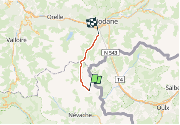

Length
16.5 km

Max alt
2439 m

Uphill gradient
735 m
Km-Effort
27 km

Min alt
1547 m

Downhill gradient
905 m
Boucle
No
Creation date :
2025-08-03 05:25:38.855
Updated on :
2025-08-03 14:41:08.723
4h14
Difficulty : Medium

FREE GPS app for hiking
 SityTrail
IGN / Geographical institutes
SityTrail Plus
The world is yours!
About
Trail Walking of 16.5 km to be discovered at Provence-Alpes-Côte d'Azur, Hautes-Alpes, Névache. This trail is proposed by catduv.
Positioning
Country:
France
Region :
Provence-Alpes-Côte d'Azur
Department/Province :
Hautes-Alpes
Municipality :
Névache
Location:
Unknown
Start:(Dec)
Start:(UTM)
313440 ; 4993100 (32T) N.
Comments