


Izé

xst
User

Length
24 km

Max alt
293 m

Uphill gradient
417 m
Km-Effort
29 km

Min alt
176 m

Downhill gradient
418 m
Boucle
Yes
Creation date :
2025-08-03 12:31:09.691
Updated on :
2025-08-03 15:33:45.671
2h12
Difficulty : Medium

FREE GPS app for hiking
 SityTrail
IGN / Geographical institutes
SityTrail Plus
The world is yours!
About
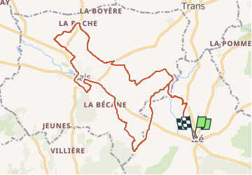
Trail Mountain bike of 24 km to be discovered at Pays de la Loire, Mayenne, Izé. This trail is proposed by xst.
Description
petite erreur de tracé.
mais bien.
A refaire.
Positioning
Country:
France
Region :
Pays de la Loire
Department/Province :
Mayenne
Municipality :
Izé
Location:
Unknown
Start:(Dec)
Start:(UTM)
699874 ; 5345454 (30U) N.
Comments