


Grimaucourt 12kms

sandra54570
User
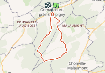

Length
12.1 km

Max alt
373 m

Uphill gradient
290 m
Km-Effort
15.9 km

Min alt
253 m

Downhill gradient
290 m
Boucle
Yes
Creation date :
2025-08-03 13:10:44.464
Updated on :
2025-08-03 16:06:57.886
2h53
Difficulty : Difficult

FREE GPS app for hiking
 SityTrail
IGN / Geographical institutes
SityTrail Plus
The world is yours!
About
Trail Walking of 12.1 km to be discovered at Grand Est, Meuse, Grimaucourt-près-Sampigny. This trail is proposed by sandra54570.
Positioning
Country:
France
Region :
Grand Est
Department/Province :
Meuse
Municipality :
Grimaucourt-près-Sampigny
Location:
Unknown
Start:(Dec)
Start:(UTM)
681299 ; 5407296 (31U) N.
Comments