


AR

MicDul
User GUIDE

Length
1.8 km

Max alt
133 m

Uphill gradient
16 m
Km-Effort
2 km

Min alt
117 m

Downhill gradient
14 m
Boucle
Yes
Creation date :
2025-08-03 16:45:54.0
Updated on :
2025-08-03 17:13:07.3
26m
Difficulty : Easy

FREE GPS app for hiking
 SityTrail
IGN / Geographical institutes
SityTrail Plus
The world is yours!
About
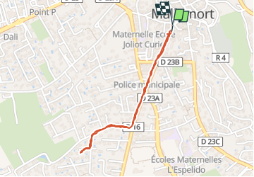
Trail Walking of 1.8 km to be discovered at Provence-Alpes-Côte d'Azur, Bouches-du-Rhône, Mallemort. This trail is proposed by MicDul.
Positioning
Country:
France
Region :
Provence-Alpes-Côte d'Azur
Department/Province :
Bouches-du-Rhône
Municipality :
Mallemort
Location:
Unknown
Start:(Dec)
Start:(UTM)
675540 ; 4844269 (31T) N.
Comments