


fraj

titi26
User
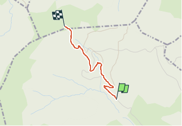

Length
1.8 km

Max alt
1715 m

Uphill gradient
245 m
Km-Effort
4.3 km

Min alt
1460 m

Downhill gradient
2 m
Boucle
No
Creation date :
2025-08-04 07:29:26.576
Updated on :
2025-08-04 08:36:52.318
1h07
Difficulty : Easy

FREE GPS app for hiking
 SityTrail
IGN / Geographical institutes
SityTrail Plus
The world is yours!
About
Trail Walking of 1.8 km to be discovered at Auvergne-Rhône-Alpes, Upper Savoy, Megève. This trail is proposed by titi26.
Description
pieton
Positioning
Country:
France
Region :
Auvergne-Rhône-Alpes
Department/Province :
Upper Savoy
Municipality :
Megève
Location:
Unknown
Start:(Dec)
Start:(UTM)
312650 ; 5082464 (32T) N.
Comments