


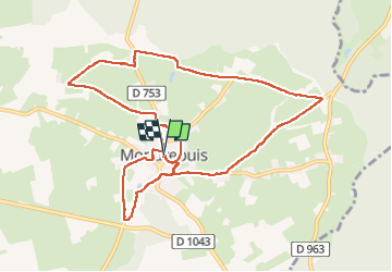
Mondrepuis

PasGoe
User

Length
10.8 km

Max alt
224 m

Uphill gradient
121 m
Km-Effort
12.5 km

Min alt
187 m

Downhill gradient
121 m
Boucle
Yes
Creation date :
2025-08-03 06:35:22.689
Updated on :
2025-08-04 08:53:21.976
3h24
Difficulty : Difficult

FREE GPS app for hiking
 SityTrail
IGN / Geographical institutes
SityTrail Plus
The world is yours!
About
Trail Walking of 10.8 km to be discovered at Hauts-de-France, Aisne, Mondrepuis. This trail is proposed by PasGoe.
Positioning
Country:
France
Region :
Hauts-de-France
Department/Province :
Aisne
Municipality :
Mondrepuis
Location:
Unknown
Start:(Dec)
Start:(UTM)
575661 ; 5535002 (31U) N.
Comments