


gta jour 26

yvesconnes
User
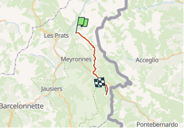

Length
22 km

Max alt
2559 m

Uphill gradient
1111 m
Km-Effort
36 km

Min alt
1669 m

Downhill gradient
1079 m
Boucle
No
Creation date :
2025-08-03 07:14:45.637
Updated on :
2025-08-04 12:06:50.026
5h15
Difficulty : Difficult

FREE GPS app for hiking
 SityTrail
IGN / Geographical institutes
SityTrail Plus
The world is yours!
About
Trail Walking of 22 km to be discovered at Provence-Alpes-Côte d'Azur, Alpes-de-Haute-Provence, Saint-Paul-sur-Ubaye. This trail is proposed by yvesconnes.
Positioning
Country:
France
Region :
Provence-Alpes-Côte d'Azur
Department/Province :
Alpes-de-Haute-Provence
Municipality :
Saint-Paul-sur-Ubaye
Location:
Unknown
Start:(Dec)
Start:(UTM)
325135 ; 4932573 (32T) N.
Comments