


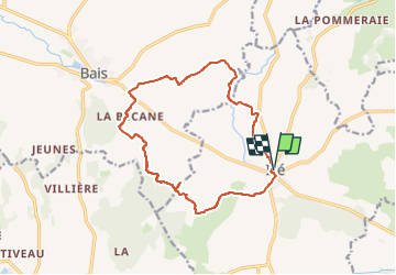
Izé/ Bais

xst
User

Length
13.8 km

Max alt
322 m

Uphill gradient
274 m
Km-Effort
17.5 km

Min alt
193 m

Downhill gradient
272 m
Boucle
Yes
Creation date :
2025-08-04 13:10:03.916
Updated on :
2025-08-04 14:35:21.125
1h19
Difficulty : Difficult

FREE GPS app for hiking
 SityTrail
IGN / Geographical institutes
SityTrail Plus
The world is yours!
About
Trail Mountain bike of 13.8 km to be discovered at Pays de la Loire, Mayenne, Izé. This trail is proposed by xst.
Description
petit circuit très jolie, mais aussi très physique.
Positioning
Country:
France
Region :
Pays de la Loire
Department/Province :
Mayenne
Municipality :
Izé
Location:
Unknown
Start:(Dec)
Start:(UTM)
699993 ; 5345477 (30U) N.
Comments