


Montfaucon en Velay

LydiaMich
User
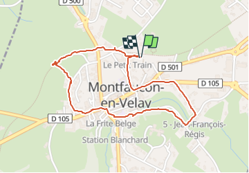

Length
2.2 km

Max alt
928 m

Uphill gradient
34 m
Km-Effort
2.6 km

Min alt
908 m

Downhill gradient
34 m
Boucle
Yes
Creation date :
2025-08-04 18:07:26.774
Updated on :
2025-08-04 18:45:56.22
38m
Difficulty : Very easy

FREE GPS app for hiking
 SityTrail
IGN / Geographical institutes
SityTrail Plus
The world is yours!
About
Trail Walking of 2.2 km to be discovered at Auvergne-Rhône-Alpes, Haute-Loire, Montfaucon-en-Velay. This trail is proposed by LydiaMich .
Description
circuit découverte
Positioning
Country:
France
Region :
Auvergne-Rhône-Alpes
Department/Province :
Haute-Loire
Municipality :
Montfaucon-en-Velay
Location:
Unknown
Start:(Dec)
Start:(UTM)
603351 ; 5004571 (31T) N.
Comments