


Tournaboup-Aigues cluses-col de Madamète-Dets Coubous

hugha
User
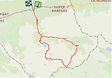

Length
19.2 km

Max alt
2561 m

Uphill gradient
1131 m
Km-Effort
34 km

Min alt
1454 m

Downhill gradient
1139 m
Boucle
Yes
Creation date :
2025-08-03 09:13:20.0
Updated on :
2025-08-05 06:15:03.096

FREE GPS app for hiking
 SityTrail
IGN / Geographical institutes
SityTrail Plus
The world is yours!
About
Trail of 19.2 km to be discovered at Occitania, Hautespyrenees, Barèges. This trail is proposed by hugha.
Description
Tournaboup-Aigues cluses-col de Madamète-col de Tracens-lac de Dets Coubous et retour.
Positioning
Country:
France
Region :
Occitania
Department/Province :
Hautespyrenees
Municipality :
Barèges
Location:
Unknown
Start:(Dec)
Start:(UTM)
263509 ; 4754150 (31T) N.
Comments