


Randonnée club Bucey 05/08/2025

FPortier
User
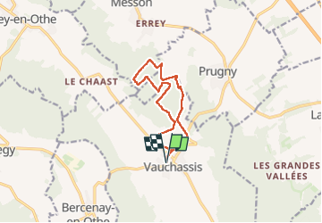

Length
10.4 km

Max alt
264 m

Uphill gradient
200 m
Km-Effort
13 km

Min alt
182 m

Downhill gradient
200 m
Boucle
Yes
Creation date :
2025-08-05 06:53:35.794
Updated on :
2025-08-05 09:54:48.379
3h00
Difficulty : Difficult

FREE GPS app for hiking
 SityTrail
IGN / Geographical institutes
SityTrail Plus
The world is yours!
About
Trail Walking of 10.4 km to be discovered at Grand Est, Aube, Vauchassis. This trail is proposed by FPortier.
Description
Randonnée chemins forêts
Positioning
Country:
France
Region :
Grand Est
Department/Province :
Aube
Municipality :
Vauchassis
Location:
Unknown
Start:(Dec)
Start:(UTM)
568467 ; 5341420 (31U) N.
Comments