


Lambesc - La Barben par les chemins

didierc13
User
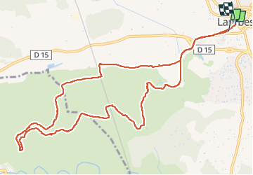

Length
13.5 km

Max alt
208 m

Uphill gradient
176 m
Km-Effort
15.8 km

Min alt
132 m

Downhill gradient
166 m
Boucle
Yes
Creation date :
2025-08-06 05:46:08.0
Updated on :
2025-08-06 08:33:24.532
2h46
Difficulty : Medium

FREE GPS app for hiking
 SityTrail
IGN / Geographical institutes
SityTrail Plus
The world is yours!
About
Trail Walking of 13.5 km to be discovered at Provence-Alpes-Côte d'Azur, Bouches-du-Rhône, Lambesc. This trail is proposed by didierc13.
Description
Très calme, chemins peu fréquentés - surveiller les autorisations d’accès aux massifs forestiers avant de partir
Positioning
Country:
France
Region :
Provence-Alpes-Côte d'Azur
Department/Province :
Bouches-du-Rhône
Municipality :
Lambesc
Location:
Unknown
Start:(Dec)
Start:(UTM)
682230 ; 4835759 (31T) N.
Comments