


cheverny

darobes
User
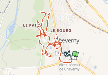

Length
3.9 km

Max alt
100 m

Uphill gradient
22 m
Km-Effort
4.2 km

Min alt
90 m

Downhill gradient
22 m
Boucle
Yes
Creation date :
2025-08-07 07:51:30.118
Updated on :
2025-08-07 10:20:46.703
2h28
Difficulty : Easy

FREE GPS app for hiking
 SityTrail
IGN / Geographical institutes
SityTrail Plus
The world is yours!
About
Trail Walking of 3.9 km to be discovered at Centre-Loire Valley, Loir-et-Cher, Cheverny. This trail is proposed by darobes.
Positioning
Country:
France
Region :
Centre-Loire Valley
Department/Province :
Loir-et-Cher
Municipality :
Cheverny
Location:
Unknown
Start:(Dec)
Start:(UTM)
384141 ; 5261624 (31T) N.
Comments