


rochetaillee court reel

6ARVAL7
User
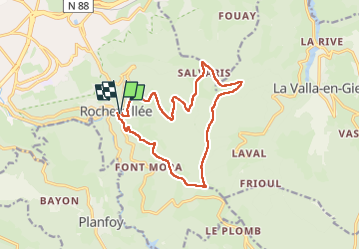

Length
14.8 km

Max alt
1094 m

Uphill gradient
564 m
Km-Effort
22 km

Min alt
764 m

Downhill gradient
561 m
Boucle
Yes
Creation date :
2025-08-07 07:02:58.144
Updated on :
2025-08-07 13:27:15.235
5h56
Difficulty : Medium

FREE GPS app for hiking
 SityTrail
IGN / Geographical institutes
SityTrail Plus
The world is yours!
About
Trail Walking of 14.8 km to be discovered at Auvergne-Rhône-Alpes, Loire, Saint-Étienne. This trail is proposed by 6ARVAL7.
Positioning
Country:
France
Region :
Auvergne-Rhône-Alpes
Department/Province :
Loire
Municipality :
Saint-Étienne
Location:
Unknown
Start:(Dec)
Start:(UTM)
613264 ; 5029501 (31T) N.
Comments