


tour du cantal

Michelraimbault
User

Length
9.2 km

Max alt
665 m

Uphill gradient
299 m
Km-Effort
13.2 km

Min alt
465 m

Downhill gradient
296 m
Boucle
Yes
Creation date :
2025-08-07 08:59:51.795
Updated on :
2025-08-07 13:42:28.172
2h54
Difficulty : Medium

FREE GPS app for hiking
 SityTrail
IGN / Geographical institutes
SityTrail Plus
The world is yours!
About
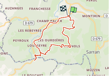
Trail Walking of 9.2 km to be discovered at Auvergne-Rhône-Alpes, Cantal, Champs-sur-Tarentaine-Marchal. This trail is proposed by Michelraimbault.
Positioning
Country:
France
Region :
Auvergne-Rhône-Alpes
Department/Province :
Cantal
Municipality :
Champs-sur-Tarentaine-Marchal
Location:
Unknown
Start:(Dec)
Start:(UTM)
465681 ; 5026900 (31T) N.
Comments