


Gromagny

Alain28/01
User

Length
19 km

Max alt
918 m

Uphill gradient
776 m
Km-Effort
29 km

Min alt
470 m

Downhill gradient
792 m
Boucle
Yes
Creation date :
2025-08-07 06:46:12.36
Updated on :
2025-08-07 13:51:24.109
4h11
Difficulty : Difficult

FREE GPS app for hiking
 SityTrail
IGN / Geographical institutes
SityTrail Plus
The world is yours!
About
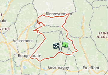
Trail Walking of 19 km to be discovered at Bourgogne-Franche-Comté, Territoire-de-Belfort, Grosmagny. This trail is proposed by Alain28/01.
Positioning
Country:
France
Region :
Bourgogne-Franche-Comté
Department/Province :
Territoire-de-Belfort
Municipality :
Grosmagny
Location:
Unknown
Start:(Dec)
Start:(UTM)
341671 ; 5289113 (32T) N.
Comments