


gta jour 27

yvesconnes
User
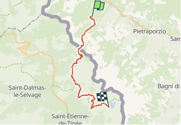

Length
23 km

Max alt
2598 m

Uphill gradient
1619 m
Km-Effort
42 km

Min alt
1871 m

Downhill gradient
998 m
Boucle
No
Creation date :
2025-08-05 06:05:04.568
Updated on :
2025-08-07 14:48:52.879
6h45
Difficulty : Difficult

FREE GPS app for hiking
 SityTrail
IGN / Geographical institutes
SityTrail Plus
The world is yours!
About
Trail Walking of 23 km to be discovered at Piemont, Cuneo, Argentera. This trail is proposed by yvesconnes.
Positioning
Country:
Italy
Region :
Piemont
Department/Province :
Cuneo
Municipality :
Argentera
Location:
Unknown
Start:(Dec)
Start:(UTM)
337034 ; 4913717 (32T) N.
Comments