


Wikiloc - Vlaams Brabant: Gaasbeek

pasvraimec
User
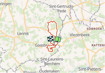

Length
10 km

Max alt
88 m

Uphill gradient
140 m
Km-Effort
11.9 km

Min alt
36 m

Downhill gradient
140 m
Boucle
Yes
Creation date :
2025-08-07 15:01:08.136
Updated on :
2025-08-09 10:38:27.369
2h42
Difficulty : Medium

FREE GPS app for hiking
 SityTrail
IGN / Geographical institutes
SityTrail Plus
The world is yours!
About
Trail Walking of 10 km to be discovered at Flanders, Flemish Brabant, Lennik. This trail is proposed by pasvraimec.
Positioning
Country:
Belgium
Region :
Flanders
Department/Province :
Flemish Brabant
Municipality :
Lennik
Location:
Gaasbeek
Start:(Dec)
Start:(UTM)
584661 ; 5628190 (31U) N.
Comments