


LA VALLÉE DE CHAUDEFOUR

JPFLOS
User

Length
37 km

Max alt
1191 m

Uphill gradient
732 m
Km-Effort
47 km

Min alt
774 m

Downhill gradient
733 m
Boucle
Yes
Creation date :
2025-08-07 11:48:41.0
Updated on :
2025-08-07 15:28:12.405
3h01
Difficulty : Unknown

FREE GPS app for hiking
 SityTrail
IGN / Geographical institutes
SityTrail Plus
The world is yours!
About
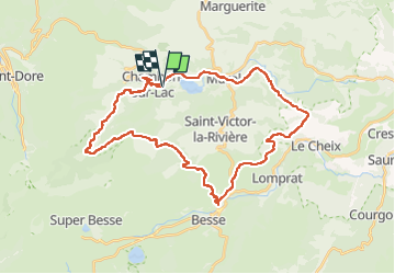
Trail Road bike of 37 km to be discovered at Auvergne-Rhône-Alpes, Puy-de-Dôme, Chambon-sur-Lac. This trail is proposed by JPFLOS.
Positioning
Country:
France
Region :
Auvergne-Rhône-Alpes
Department/Province :
Puy-de-Dôme
Municipality :
Chambon-sur-Lac
Location:
Unknown
Start:(Dec)
Start:(UTM)
492535 ; 5046249 (31T) N.
Comments