


entre deux lacs

Wilfried Boultareau
User
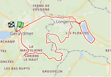

Length
27 km

Max alt
1045 m

Uphill gradient
537 m
Km-Effort
34 km

Min alt
655 m

Downhill gradient
538 m
Boucle
Yes
Creation date :
2025-08-07 13:21:36.768
Updated on :
2025-08-07 16:45:15.438
3h23
Difficulty : Difficult

FREE GPS app for hiking
 SityTrail
IGN / Geographical institutes
SityTrail Plus
The world is yours!
About
Trail Mountain bike of 27 km to be discovered at Grand Est, Vosges, Gérardmer. This trail is proposed by Wilfried Boultareau.
Positioning
Country:
France
Region :
Grand Est
Department/Province :
Vosges
Municipality :
Gérardmer
Location:
Unknown
Start:(Dec)
Start:(UTM)
341455 ; 5326478 (32U) N.
Comments