


Hourquette d'Ancizan Pla del Naou Col d'Aspin Col de Beyrede Col d'Aspin

JMFr
User
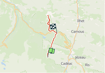

Length
16.6 km

Max alt
1749 m

Uphill gradient
811 m
Km-Effort
28 km

Min alt
1419 m

Downhill gradient
883 m
Boucle
No
Creation date :
2025-08-08 04:25:07.861
Updated on :
2025-08-08 12:56:08.537
3h44
Difficulty : Medium

FREE GPS app for hiking
 SityTrail
IGN / Geographical institutes
SityTrail Plus
The world is yours!
About
Trail Walking of 16.6 km to be discovered at Occitania, Hautespyrenees, Ancizan. This trail is proposed by JMFr.
Positioning
Country:
France
Region :
Occitania
Department/Province :
Hautespyrenees
Municipality :
Ancizan
Location:
Unknown
Start:(Dec)
Start:(UTM)
279977 ; 4753268 (31T) N.
Comments