


tour en gravel

bernardcornu
User

Length
40 km

Max alt
669 m

Uphill gradient
418 m
Km-Effort
45 km

Min alt
421 m

Downhill gradient
414 m
Boucle
Yes
Creation date :
2025-08-09 07:23:43.528
Updated on :
2025-08-09 09:56:43.355
2h22
Difficulty : Very difficult

FREE GPS app for hiking
 SityTrail
IGN / Geographical institutes
SityTrail Plus
The world is yours!
About
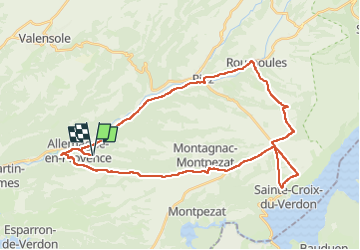
Trail Road bike of 40 km to be discovered at Provence-Alpes-Côte d'Azur, Alpes-de-Haute-Provence, Allemagne-en-Provence. This trail is proposed by bernardcornu.
Description
1 quart sur piste caillouteuse
Positioning
Country:
France
Region :
Provence-Alpes-Côte d'Azur
Department/Province :
Alpes-de-Haute-Provence
Municipality :
Allemagne-en-Provence
Location:
Unknown
Start:(Dec)
Start:(UTM)
260055 ; 4851726 (32T) N.
Comments