


fin truc

pablo92
User
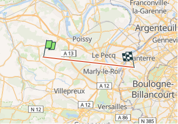

Length
19.1 km

Max alt
195 m

Uphill gradient
258 m
Km-Effort
23 km

Min alt
19 m

Downhill gradient
373 m
Boucle
No
Creation date :
2025-08-08 14:13:24.911
Updated on :
2025-08-10 09:18:40.174
9m
Difficulty : Very difficult

FREE GPS app for hiking
 SityTrail
IGN / Geographical institutes
SityTrail Plus
The world is yours!
About
Trail Walking of 19.1 km to be discovered at Ile-de-France, Yvelines, Crespières. This trail is proposed by pablo92.
Positioning
Country:
France
Region :
Ile-de-France
Department/Province :
Yvelines
Municipality :
Crespières
Location:
Unknown
Start:(Dec)
Start:(UTM)
422022 ; 5416361 (31U) N.
Comments