


roanne saintbenoit reel

lerouge8726
User
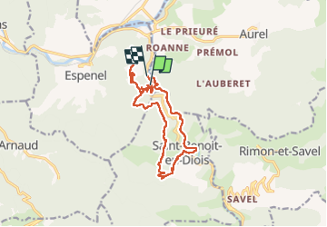

Length
16.6 km

Max alt
675 m

Uphill gradient
601 m
Km-Effort
25 km

Min alt
307 m

Downhill gradient
607 m
Boucle
No
Creation date :
2025-08-10 07:10:07.254
Updated on :
2025-08-10 20:03:10.949
3h59
Difficulty : Easy

FREE GPS app for hiking
 SityTrail
IGN / Geographical institutes
SityTrail Plus
The world is yours!
About
Trail Walking of 16.6 km to be discovered at Auvergne-Rhône-Alpes, Drôme, Espenel. This trail is proposed by lerouge8726.
Positioning
Country:
France
Region :
Auvergne-Rhône-Alpes
Department/Province :
Drôme
Municipality :
Espenel
Location:
Unknown
Start:(Dec)
Start:(UTM)
679047 ; 4950029 (31T) N.
Comments