


l’Echalp - Jervis

edevuyst
User
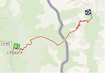

Length
6.8 km

Max alt
2312 m

Uphill gradient
608 m
Km-Effort
14.8 km

Min alt
1699 m

Downhill gradient
570 m
Boucle
No
Creation date :
2025-08-11 09:21:25.0
Updated on :
2025-08-11 14:06:15.602
2h30
Difficulty : Difficult

FREE GPS app for hiking
 SityTrail
IGN / Geographical institutes
SityTrail Plus
The world is yours!
About
Trail Walking of 6.8 km to be discovered at Provence-Alpes-Côte d'Azur, Hautes-Alpes, Abriès-Ristolas. This trail is proposed by edevuyst.
Positioning
Country:
France
Region :
Provence-Alpes-Côte d'Azur
Department/Province :
Hautes-Alpes
Municipality :
Abriès-Ristolas
Location:
Ristolas
Start:(Dec)
Start:(UTM)
341134 ; 4958163 (32T) N.
Comments