


Estaubé-Tuquerouye

hugha
User

Length
23 km

Max alt
2694 m

Uphill gradient
1446 m
Km-Effort
42 km

Min alt
1658 m

Downhill gradient
1447 m
Boucle
Yes
Creation date :
2025-08-11 03:46:49.0
Updated on :
2025-08-11 17:34:14.145
9h30
Difficulty : Very difficult

FREE GPS app for hiking
 SityTrail
IGN / Geographical institutes
SityTrail Plus
The world is yours!
About
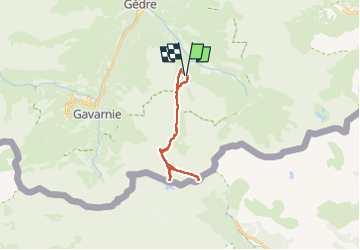
Trail Walking of 23 km to be discovered at Occitania, Hautespyrenees, Gavarnie-Gèdre. This trail is proposed by hugha.
Description
Montée vers le refuge de Tuquerouye arrêtée à 60 m du refuge cause névé. La montée dans ces éboulis est TRÈS raide. Changement de programme pour continuer vers Port Neuf de Pinède
Positioning
Country:
France
Region :
Occitania
Department/Province :
Hautespyrenees
Municipality :
Gavarnie-Gèdre
Location:
Gèdre
Start:(Dec)
Start:(UTM)
258739 ; 4737431 (31T) N.
Comments