


sortir elo arno

marcagif
User
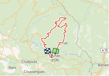

Length
59 km

Max alt
1309 m

Uphill gradient
1392 m
Km-Effort
78 km

Min alt
417 m

Downhill gradient
1391 m
Boucle
Yes
Creation date :
2025-08-11 06:40:54.114
Updated on :
2025-08-12 07:19:11.435
24h37
Difficulty : Medium

FREE GPS app for hiking
 SityTrail
IGN / Geographical institutes
SityTrail Plus
The world is yours!
About
Trail Road bike of 59 km to be discovered at Occitania, Aveyron, Sainte-Eulalie-d'Olt. This trail is proposed by marcagif.
Positioning
Country:
France
Region :
Occitania
Department/Province :
Aveyron
Municipality :
Sainte-Eulalie-d'Olt
Location:
Unknown
Start:(Dec)
Start:(UTM)
496610 ; 4922674 (31T) N.
Comments