


sion March'ettes août 25

lacote
User
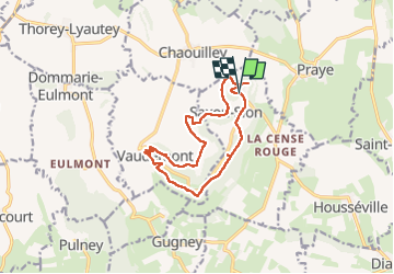

Length
12.4 km

Max alt
532 m

Uphill gradient
273 m
Km-Effort
16 km

Min alt
352 m

Downhill gradient
271 m
Boucle
Yes
Creation date :
2025-08-12 07:20:38.361
Updated on :
2025-08-12 12:50:49.637
4h45
Difficulty : Difficult

FREE GPS app for hiking
 SityTrail
IGN / Geographical institutes
SityTrail Plus
The world is yours!
About
Trail Walking of 12.4 km to be discovered at Grand Est, Meurthe-et-Moselle, Saxon-Sion. This trail is proposed by lacote.
Positioning
Country:
France
Region :
Grand Est
Department/Province :
Meurthe-et-Moselle
Municipality :
Saxon-Sion
Location:
Unknown
Start:(Dec)
Start:(UTM)
284212 ; 5368187 (32U) N.
Comments