


Col de la Lauze et Col de Montségur depuis Celles

chrisbal
User
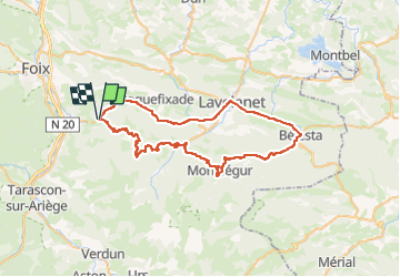

Length
62 km

Max alt
1061 m

Uphill gradient
1299 m
Km-Effort
80 km

Min alt
465 m

Downhill gradient
1301 m
Boucle
Yes
Creation date :
2025-08-13 07:23:55.657
Updated on :
2025-08-13 07:23:56.768
4h49
Difficulty : Difficult

FREE GPS app for hiking
 SityTrail
IGN / Geographical institutes
SityTrail Plus
The world is yours!
About
Trail Road bike of 62 km to be discovered at Occitania, Ariège, Celles. This trail is proposed by chrisbal.
Positioning
Country:
France
Region :
Occitania
Department/Province :
Ariège
Municipality :
Celles
Location:
Unknown
Start:(Dec)
Start:(UTM)
392684 ; 4752398 (31T) N.
Comments