


Ens Pic de Hountas retour par Artiguemoure

JMFr
User
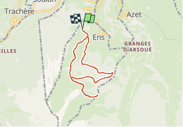

Length
7.5 km

Max alt
1751 m

Uphill gradient
485 m
Km-Effort
14 km

Min alt
1270 m

Downhill gradient
486 m
Boucle
Yes
Creation date :
2025-08-13 04:52:29.117
Updated on :
2025-08-13 08:28:26.379
1h28
Difficulty : Medium

FREE GPS app for hiking
 SityTrail
IGN / Geographical institutes
SityTrail Plus
The world is yours!
About
Trail Walking of 7.5 km to be discovered at Occitania, Hautespyrenees, Ens. This trail is proposed by JMFr.
Positioning
Country:
France
Region :
Occitania
Department/Province :
Hautespyrenees
Municipality :
Ens
Location:
Unknown
Start:(Dec)
Start:(UTM)
282093 ; 4742956 (31T) N.
Comments