


20250813 Ubud

Childebert
User

Length
112 km

Max alt
1367 m

Uphill gradient
2204 m
Km-Effort
142 km

Min alt
39 m

Downhill gradient
2204 m
Boucle
Yes
Creation date :
2025-08-13 00:54:47.719
Updated on :
2025-08-13 11:45:27.531
11h48
Difficulty : Medium

FREE GPS app for hiking
 SityTrail
IGN / Geographical institutes
SityTrail Plus
The world is yours!
About
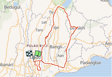
Trail Walking of 112 km to be discovered at Bali, Ubud. This trail is proposed by Childebert.
Positioning
Country:
Indonesia
Region :
Bali
Department/Province :
Ubud
Municipality :
Unknown
Location:
Unknown
Start:(Dec)
Start:(UTM)
308085 ; 9057609 (50L) S.
Comments