


13/08/2025 - Tour Ile de Brehat.Virtuel

babeth35
User

Length
16.7 km

Max alt
29 m

Uphill gradient
220 m
Km-Effort
19.6 km

Min alt
1 m

Downhill gradient
221 m
Boucle
Yes
Creation date :
2025-08-13 15:15:22.755
Updated on :
2025-08-13 16:23:24.079
4h27
Difficulty : Easy
4h27
Difficulty : Very difficult

FREE GPS app for hiking
 SityTrail
IGN / Geographical institutes
SityTrail Plus
The world is yours!
About
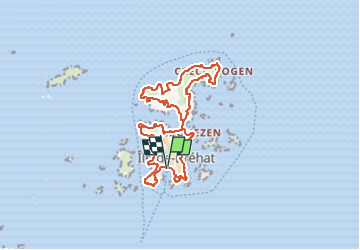
Trail On foot of 16.7 km to be discovered at Brittany, Côtes-d'Armor, Île-de-Bréhat. This trail is proposed by babeth35.
Positioning
Country:
France
Region :
Brittany
Department/Province :
Côtes-d'Armor
Municipality :
Île-de-Bréhat
Location:
Unknown
Start:(Dec)
Start:(UTM)
499736 ; 5409749 (30U) N.
Comments