


TOUR DE BZH ETAPE 1 J N°2

rousseau.mich
User

Length
15.8 km

Max alt
42 m

Uphill gradient
213 m
Km-Effort
18.7 km

Min alt
4 m

Downhill gradient
240 m
Boucle
No
Creation date :
2015-08-24 00:00:00.0
Updated on :
2015-08-24 00:00:00.0
3h19
Difficulty : Unknown

FREE GPS app for hiking
 SityTrail
IGN / Geographical institutes
SityTrail Plus
The world is yours!
About
Trail Nordic walking of 15.8 km to be discovered at Brittany, Ille-et-Vilaine, Cancale. This trail is proposed by rousseau.mich.
Description
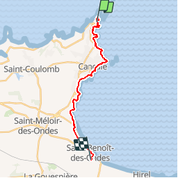
DE LA POINTE DU GROUIN AU CAMPING DE L'ILE VERTE ST BENOIT DES ONDES
Positioning
Country:
France
Region :
Brittany
Department/Province :
Ille-et-Vilaine
Municipality :
Cancale
Location:
Unknown
Start:(Dec)
Start:(UTM)
584861 ; 5395487 (30U) N.
Comments