


xette liezey thole haut du tot

cetmlchabert
User
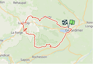

Length
33 km

Max alt
913 m

Uphill gradient
857 m
Km-Effort
44 km

Min alt
526 m

Downhill gradient
862 m
Boucle
Yes
Creation date :
2025-08-14 07:18:59.475
Updated on :
2025-08-14 10:14:54.48
2h55
Difficulty : Very difficult

FREE GPS app for hiking
 SityTrail
IGN / Geographical institutes
SityTrail Plus
The world is yours!
About
Trail Road bike of 33 km to be discovered at Grand Est, Vosges, Gérardmer. This trail is proposed by cetmlchabert.
Positioning
Country:
France
Region :
Grand Est
Department/Province :
Vosges
Municipality :
Gérardmer
Location:
Unknown
Start:(Dec)
Start:(UTM)
340835 ; 5326776 (32U) N.
Comments