


Parc de Saint Cloud

maxEA65
User
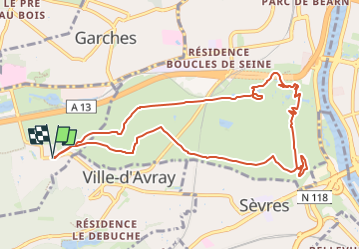

Length
10 km

Max alt
169 m

Uphill gradient
208 m
Km-Effort
12.8 km

Min alt
38 m

Downhill gradient
209 m
Boucle
Yes
Creation date :
2025-08-16 14:41:30.337
Updated on :
2025-08-16 14:42:34.689
2h54
Difficulty : Difficult

FREE GPS app for hiking
 SityTrail
IGN / Geographical institutes
SityTrail Plus
The world is yours!
About
Trail Walking of 10 km to be discovered at Ile-de-France, Hauts-de-Seine, Marnes-la-Coquette. This trail is proposed by maxEA65.
Positioning
Country:
France
Region :
Ile-de-France
Department/Province :
Hauts-de-Seine
Municipality :
Marnes-la-Coquette
Location:
Unknown
Start:(Dec)
Start:(UTM)
439551 ; 5408898 (31U) N.
Comments