


Tour du Lac de Pierre Percée

francoisecarlier
User
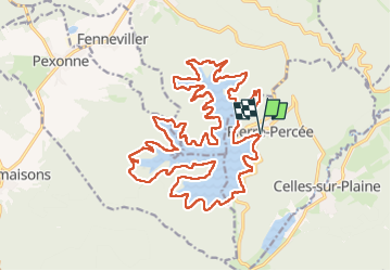

Length
28 km

Max alt
440 m

Uphill gradient
504 m
Km-Effort
35 km

Min alt
373 m

Downhill gradient
504 m
Boucle
Yes
Creation date :
2025-08-17 08:01:18.0
Updated on :
2025-08-17 14:49:32.258

FREE GPS app for hiking
 SityTrail
IGN / Geographical institutes
SityTrail Plus
The world is yours!
About
Trail of 28 km to be discovered at Grand Est, Meurthe-et-Moselle, Pierre-Percée. This trail is proposed by francoisecarlier.
Positioning
Country:
France
Region :
Grand Est
Department/Province :
Meurthe-et-Moselle
Municipality :
Pierre-Percée
Location:
Unknown
Start:(Dec)
Start:(UTM)
346968 ; 5370363 (32U) N.
Comments