


180725

JeanLucA4
User
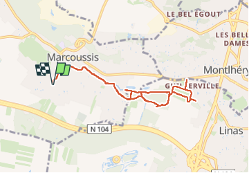

Length
10.3 km

Max alt
90 m

Uphill gradient
92 m
Km-Effort
11.5 km

Min alt
59 m

Downhill gradient
92 m
Boucle
Yes
Creation date :
2025-08-18 03:34:15.0
Updated on :
2025-08-18 05:53:03.781
2h17
Difficulty : Medium

FREE GPS app for hiking
 SityTrail
IGN / Geographical institutes
SityTrail Plus
The world is yours!
About
Trail Walking of 10.3 km to be discovered at Ile-de-France, Essonne, Marcoussis. This trail is proposed by JeanLucA4.
Positioning
Country:
France
Region :
Ile-de-France
Department/Province :
Essonne
Municipality :
Marcoussis
Location:
Unknown
Start:(Dec)
Start:(UTM)
442992 ; 5387517 (31U) N.
Comments